Was Colorado Really a Part of Mexico at One Time?
Was a portion of Colorado originally part of Mexico at one time? Indeed it was!
Not only was the state once part of Mexico, but the same portion of Colorado that used to belong to Mexico also became part of the Republic of Texas when it gained independence in the 1830s.

Was Colorado Part of Mexico at One Time?
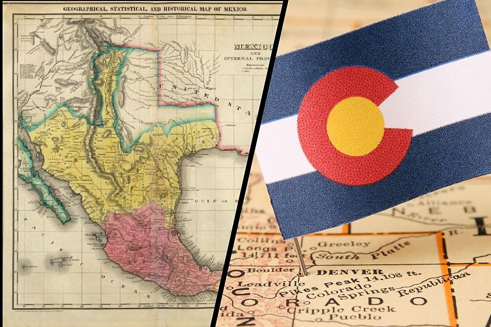
Thanks to Mapgeeks.org we can go all the way back to the maps of Old Mexico (1822) to be able to see this is accurate. Before Mexico gained independence from Spain explorers traveled up into parts of Colorado mining gold and establishing the Old Spanish Trail. Once Mexico gained independence, this part of Spanish territory (including a slice of Colorado) went to Mexico.
State Map of Texas Territory Showing Mexico, California and Parts of Colorado
The map above comes right after the establishment of the Republic of Mexico in May of 1823. Portions of what once was 'New Spain' were now Mexico extending up to Northern California and included a portion of Colorado.
1827 Map of Mexico Including Texas and Northern California
You can see that in 1827, Mexico extended far to the North and followed the Front Range into Colorado. The Spanish followed trails North from Mexico into New Mexico and Colorado with tales of golden cities located throughout the pueblo areas of New Mexico and even more mines in the mountains of Colorado.
Was Colorado Part of Texas at One Time?
By January of 1836, there was a battle coming to the Alamo in San Antonio. Mexican forces squared off against defenders of the Texas territory in a series of battles that would ultimately lead to Texas declaring Independence from Mexico. Important for Colorado was that when Texas broke away from Mexico they wanted all the land in the Texas territory to come with it including that slice of the Colorado Front Range.
See Colorado's Transformation from a Territory to a State
It took almost 30 years from the time of Texas Independence to the time the Colorado territory was established in 1861.
Scrolling through the photo gallery of maps below, we can see how the Kansas and Nebraska territories helped shape what was left of the Texas territories, and how all of this became the state of Colorado by 1876.
MAPS: See How Colorados County Maps Evolved from 1850 to Today
KEEP GOING: Grand Junction Historical Facts You May or May Not Know
Travel Back in Time and Visit These historic Places Around Colorado's Mesa County
More From 99.9 The Point


